Proposed Local Green Space at Bury Moor Fields (Land Behind the Moors)
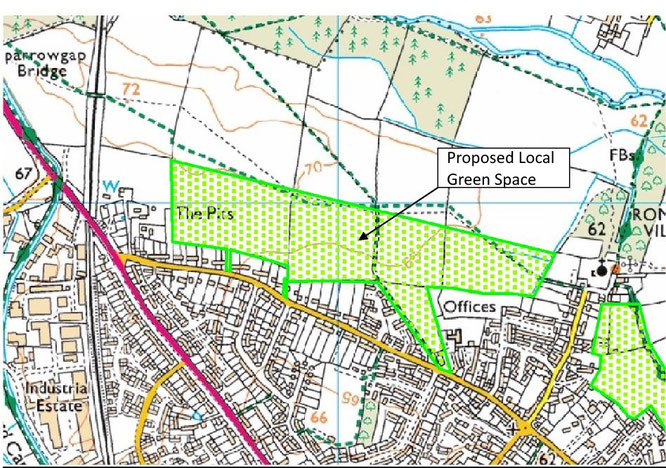
This is one of the two specific local green spaces proposed by KDW north and north-east of the village. The site is shown on the map below.
(Note that after crossing the easternmost field as shown, the E-W footpath, in practice, follows the boundary of the proposed LGS rather than the green dashed lines indicated on the map)
National Planning Policy Framework (NPPF) Criteria.
The area meets the NPPF criteria for designation as LGS, as follows:
Proximity to the local community
The area consists of five fields immediately adjacent to the built up area of Kidlington. There are several well-used access points from the nearby roads and two public rights of way cross and run along the proposed area. In addition, every field boundary has informal paths along it, demonstrating how extensively the area is used by the local community.
Historic significance
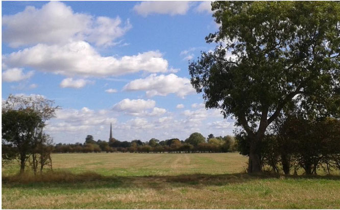
Kidlington is unusual in that its parish church is situated on the extremity of the village, on a slightly elevated site at the end of an area of terraced river gravels which runs along Church Street. St Mary’s Church is Grade 1 listed, dates back 800 years and has an exceptionally tall and slender steeple (known as ‘Our Lady’s Needle’). It is the final building on the northern edge of the village and is almost surrounded by fields, with the exception of houses at the northern end of Church Street. As the surrounding land is low-lying, the church is visible from considerable distances. When seen from many directions it appears to be set amongst fields. The west-east centre line of the proposed LGS aligns with the church as can be seen from the picture below. The setting of this important historic building would clearly be damaged by development in these fields.
Kidlington Historical Society comments that : “the landscape is a good example of post-enclosure Kidlington, with most of the field boundaries those set out on the Enclosure Map. The age of the hedges will be an indication of their value for wildlife. There is an ancient (possibly Roman) well just north of the area, in Ashpit. It's an odd place to find a well, right on top of the cornbrash ridge running down to the Church, so there may be archaeology around it, extending into the proposed LGS. This area is part of the setting of St Mary's with delightful views down the ridge towards the church from the footpath to Sparrowgap Bridge. The LGS would preserve these for future generations.”
Recreational value
The site is crossed and bounded by two popular footpaths which are very well used by local people and visiting walkers. These are both enclosure awards from 1818 and should be maintained to a width of ten feet, though in practice they are not. The east-west path leads from the church towards the canal bridge near the Jolly Boatman public house next to the Banbury Road. The SE-NW path leads from the Moors to the Community Woodland and Canal Basin at Thrupp. A key attraction of these paths is that they cross open countryside and have fine views east to St Mary’s Church.
In addition to this, almost every field boundary, including along the rear boundaries of houses on the Moors, is lined by informal paths which are regularly used for recreation by large numbers of local people.
Beauty, Tranquillity and Richness of Wildlife
The site is in attractive open countryside (see photo above) which leads to the Cherwell Meadows Conservation Target Area and the River Cherwell itself. There are almost no buildings until the nearest villages are reached and no through roads. Consequently the area is tranquil and has the feel of being part of the countryside. This is not the case almost anywhere else on the village boundary.
The fields are relatively small and bounded by hedges and trees which therefore support a variety of wildlife, particularly birds and including rare wildlife species such as Short Eared Owls (on the RSPB amber list), and Skylarks (on the RSPB red list). Other bird species noted by local residents include goldfinch, greenfinch, redstart, jay, spotted woodpecker, green woodpecker, tree creeper, dunnock, cuckoos and various birds of prey and owls. Foxes and Deer are also frequently seen in the area and smaller animals include weasels, field mice adders and grass snakes. At the point where the SE-NW footpath joins the Moors there is a small pond surrounded by scrub which, although now rather neglected, was maintained for many years for nature conservation and would benefit from restoration. Great Crested Newts have been found here in the past.
The site is close to the Cherwell Valley Conservation Target Area and to the St Mary’s Fields Local Nature Reserve. It can therefore also be considered to be a protective buffer and corridor to these important habitats.
Local in Character
Guidance says that the site should not be extensive in nature but does not define extensive. In our view the proposed site is not extensive, certainly when compared to the areas of land that have already been removed from the Green Belt or from sites that are being put forward for development at the moment. We are aware of examples elsewhere of larger sites which local authorities have deemed suitable as LGS (see for example Bulmershe and Fox Hill sites in Wokingham’s 2020 Local Green Space Topic Paper). While it extends over several fields, the width of the proposed LGS is limited to that of one modest field, and all of it meets the criteria set out above.
Important. We consider that this is not an extensive area. However, if the proposed area is deemed to be too extensive, it should not simply be rejected. Instead, consideration should be given to designating individual fields (or combinations of fields) as LGS.